útikönyv Press
| Találatok száma: 374 | 1/19. oldal | Rendezés: |
-
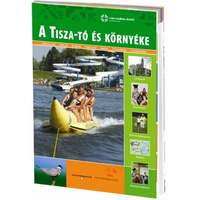 Well-Press kiadó A Tisza-tó és környéke útikönyv Well-Press kiadóTisza-tó útikönyv, Tisza tó útikönyv3.200 Ft
-
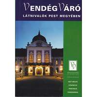 Well-Press kiadó Látnivalók Pest megyében útikönyv Well-Press kiadóPest megye útikönyv3.200 Ft
 -
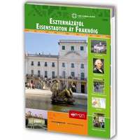 Well-Press kiadó Eszterházától Eisenstadton át Fraknóig Vendégváró útikönyv Well-Press kiadó3.200 Ft
 -
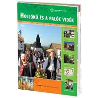 Well-Press kiadó Hollókő és a Palóc vidék útikönyv Well-Press kiadóHollókő útikönyv3.200 Ft
 -
 Well-Press kiadó Salgótarján Vendégváró útikönyv Well-Press kiadó3.200 Ft
 -
 Well-Press kiadó Barangolások Csongrád megyében Vendégváró útikönyv Well-Press kiadó3.200 Ft
 -
 Well-Press kiadó Látnivalók Szabolcs-Szatmár-Bereg megyében útikönyv Vendégváró Well-Press kiadó3.500 Ft
 -
 Well-Press kiadó Látnivalók Magyarországon Vendégváró útikönyv Well-Press - francia nyelven4.990 Ft
 -
 Cicerone Press The Ridgeway Map Booklet Cicerone túrakalauz, útikönyv - angolSouthern England 1:25,000 OS Route Mapping British Long Distance Map of the 87 mile (139km) Ridgeway National Trail through the south of England from Avebury in Wiltshire to Ivinghoe Beacon in Buckinghamshire. This booklet is included with the Cicerone6.500 Ft
 -
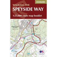 Cicerone Press The Speyside Way Map Booklet Cicerone túrakalauz, útikönyv - angolScotland 1:25,000 OS Route Mapping British Long Distance Map of Scotland's Speyside Way, a 66 mile walk which follows the River Spey from Aviemore to Buckie. This booklet is included with the Cicerone guidebook to the trail, and shows the full route on6.500 Ft
 -
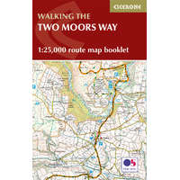 Cicerone Press Two Moors Way Map Booklet Cicerone túrakalauz, útikönyv - angolSouthern England 1:25,000 OS Route Mapping British Long Distance Map booklet for Devon's Coast to Coast, a 117 mile route incorporating the Two Moors Way and a section of the Erme-Plym Trail. This booklet is included with the Cicerone guide to the trai6.500 Ft
 -
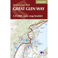 Cicerone Press The Great Glen Way Map Booklet Cicerone túrakalauz, útikönyv - angolScotland 1:25,000 OS Route Mapping British Long Distance Map of the 79 mile (124km) Great Glen Way (one of Scotland's Great Trails), between Fort William and Inverness. This booklet is included with the Cicerone guidebook to the trail, and shows the fu6.500 Ft
 -
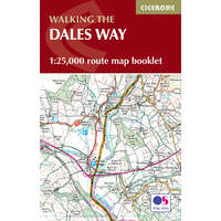 Cicerone Press The Dales Way Map Booklet Cicerone túrakalauz, útikönyv - angolNorthern England Routes British Long Distance Map of the 79 mile (127km) Dales Way through the Yorkshire Dales between Ilkley and Bowness-on-Windermere. This booklet is included with the Cicerone guidebook and shows the full route on OS 1:25K maps. On6.500 Ft
 -
 Cicerone Press Walking in the Forest of Bowland and Pendle Cicerone túrakalauz, útikönyv - angolNorth-West England and The Isle of Man 40 walks in Lancashire's Area of Outstanding Natural Beauty British Walking A guidebook to 40 diverse circular day walks suitable for walkers with navigational skills. The Forest of Bowland and Pendle are two of8.500 Ft
 -
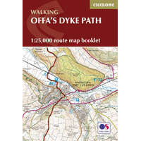 Cicerone Press Offa's Dyke Map Booklet Cicerone túrakalauz, útikönyv - angolWales and Welsh Borders 1:25,000 OS Route Mapping British Long Distance Map of the 177 mile (283km) Offa's Dyke Path National Trail, between Sedbury (near Chepstow) and Prestatyn. The trail takes 2 weeks to walk, and is suitable for walkers at all leve8.500 Ft
 -
 Cicerone Press Cycling the Reivers Route Cicerone túrakalauz, útikönyv - angolNorthern England Routes Coast to coast through wild Northumberland's border country Cycling and cycle touring Guidebook to the Reivers Route, a 173 mile (280km) coast-to-coast cycle route across northern England and into Scotland from Tynemouth to Whit8.500 Ft
 -
 Cicerone Press Cycling Lon Las Cymru Cicerone túrakalauz, útikönyv - angolWales and Welsh Borders 250 miles through the heart of Wales on traffic-free paths and quiet roads Cycling and cycle touring Guidebook to cycling L√¥n Las Cymru, a 255 mile (410km) route from Cardiff, or 242 miles (390km) from Chepstow to Holyhead, sho8.500 Ft
 -
 Cicerone Press Navigation Cicerone túrakalauz, útikönyv - angolMini Guides Techniques and skills for walkers Techniques This pocket handbook to navigation will help you master the necessary map and compass skills for mountain walking. Chapters include map scales, symbols and contours, grid references, map reading,8.500 Ft
 -
 Cicerone Press Snow Cicerone túrakalauz, útikönyv - angolMini Guides Understanding, testing and interpreting snow conditions to make better avalanche predictions Techniques This practical guidebook is aimed at anyone who wants to acquire or improve their knowledge of snow and avalanche release. It describes8.500 Ft
 -
 Cicerone Press Snowdonia: 30 Low-level and Easy Walks - North Cicerone túrakalauz, útikönyv - angolWales and Welsh Borders Snowdon, the Ogwen and Conwy Valleys and the coast British Walking Guidebook describing 30 walks in Snowdonia, Wales. Routes are mostly low level and on clear paths and showcase the region's beautiful scenery and rich history an8.500 Ft